
Accurate Visual Representations (AVRs)
What is an accurate visual representation?
An Accurate Visual Representation is a calibrated image that shows how a proposed development will appear in its real location. It combines precise photography, survey data and 3D modelling to ensure the visual outcome is both measured and verifiable.
AVRs are frequently required for planning submissions because they provide:
- Visual clarity for planners and stakeholders
- Transparent communication of visual impact
- A fair basis for assessing change in townscape, heritage and landscape settings
Depending on the level of detail required, Verified Views are produced at Level 0–3, ranging from basic massing to full photorealistic render integration.
In simple terms: Verified Views build trust – they allow planning teams to see exactly what will be built, from exactly where

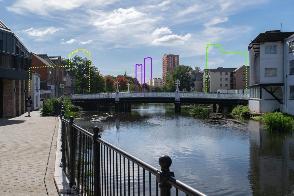
AVR (Level) 0 – Wireline
Location and size of proposal, does not include degree of visibility.

AVR (Level) 1 – Wireline
Location, size and degree of visibility of proposal.
An outline wireline with a translucent fill to visible areas and often, supporting internal lines to explain basic form. Dashed-line where occluded. Usually does not include landscape or vegetation proposals.

AVR (Level) 2- Clay
As level 1 + description of architectural form.
Rendered with a single colour in an accurately lit environment. Masked out where occluded. Occasionally includes hard landscape proposals. Usually does not include vegetation.

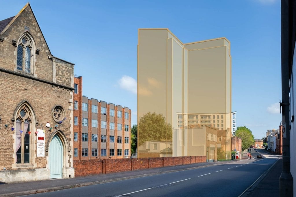
AVR (Level) 3 – Rendered
As level 2 + use of materials
Rendered with physically based realistic materials in an accurately lit environment. Masked out where occluded. Includes all aspects of proposed landscaping and vegetation.
Why Accuracy and Visual Impact Matters
Planning decisions rely on evidence. When a development affects views or sensitive locations, accuracy is critical – not interpretation.
Accurate Visual Representations enable:
- A reliable assessment of visual impact
- Clarity in locations with heritage sensitivity or protected views
- Confidence that design changes are evaluated using factual data
Because our imagery is tied back to survey data, it can be traced, measured and defended if challenged. This reduces ambiguity in the planning process and helps clients move projects forward with clarity and confidence.
Accuracy isn’t just a technical requirement – it’s a planning advantage
How We Produce Verified Views
Our workflow is designed to be exact, transparent, and defensible. Every Verified View follows a structured methodology:
- Photography
- High-resolution photography captured with an appropriate focal length and projection dependent on specific project requirements.
- Survey coordination
- The camera locations and a selection of features from the photo are accurately surveyed and processed into geographical data.
- Camera matching & alignment
- The survey data is imported into the 3D environment by means of a bespoke script, relative to the OSGB36 coordinate system. Virtual cameras are placed at the coordinates provided by the surveyor. Renders are created from each of the virtual cameras and aligned to the photography.
- Model integration
- A proposed scheme model is imported and positioned via the same coordinate system and rendered through the virtual cameras placed via the survey data.
- Treatment & Documentation
- The renders are treated according to the required AVR level required and packaged into a complete methodology document ready for submission.
We work directly with architects, planning consultants and surveyors to ensure absolute accuracy from data capture to final image.
The result: visualisations that are not only compelling, but also technically and legally robust
Confidence Through Verified Methodology
Every Verified View we produce follows a repeatable and documented process. This means our clients – and their planning teams – can demonstrate how the visuals were created, how the view was controlled, and how accuracy was maintained.
- Fully traceable data from site capture to delivery
- Outputs that withstand planning scrutiny
- Clear justification of visual impact and design intent
Our verified methodology removes uncertainty from the process, enabling better communication, quicker approvals and smoother stakeholder engagement.
Visual Horizon use a methodology that is guided by the relevant sections of:
You get visuals that are beautiful – and visuals that stand up to scrutiny
Accurate Visual Representations (AVRs)
What is an accurate visual representation?
An Accurate Visual Representation is a calibrated image that shows how a proposed development will appear in its real location. It combines precise photography, survey data and 3D modelling to ensure the visual outcome is both measured and verifiable.
AVRs are frequently required for planning submissions because they provide:
- Visual clarity for planners and stakeholders
- Transparent communication of visual impact
- A fair basis for assessing change in townscape, heritage and landscape settings
Depending on the level of detail required, Verified Views are produced at Level 0–3, ranging from basic massing to full photorealistic render integration.
In simple terms: Verified Views build trust – they allow planning teams to see exactly what will be built, from exactly where
AVR (Level) 0 – Wireline
Location and size of proposal, does not include degree of visibility.
AVR (Level) 1 – Wireline
Location, size and degree of visibility of proposal.
An outline wireline with a translucent fill to visible areas and often, supporting internal lines to explain basic form. Dashed-line where occluded. Usually does not include landscape or vegetation proposals.
AVR (Level) 2- Clay
As level 1 + description of architectural form.
Rendered with a single colour in an accurately lit environment. Masked out where occluded. Occasionally includes hard landscape proposals. Usually does not include vegetation.
AVR (Level) 3 – Rendered
As level 2 + use of materials
Rendered with physically based realistic materials in an accurately lit environment. Masked out where occluded. Includes all aspects of proposed landscaping and vegetation.
Why Accuracy and Visual Impact Matters
Planning decisions rely on evidence. When a development affects views or sensitive locations, accuracy is critical – not interpretation.
Accurate Visual Representations enable:
- A reliable assessment of visual impact
- Clarity in locations with heritage sensitivity or protected views
- Confidence that design changes are evaluated using factual data
Because our imagery is tied back to survey data, it can be traced, measured and defended if challenged. This reduces ambiguity in the planning process and helps clients move projects forward with clarity and confidence.
Accuracy isn’t just a technical requirement – it’s a planning advantage
How We Produce Verified Views
Our workflow is designed to be exact, transparent, and defensible. Every Verified View follows a structured methodology:
- Photography
- High-resolution photography captured with an appropriate focal length and projection dependent on specific project requirements.
- Survey coordination
- The camera locations and a selection of features from the photo are accurately surveyed and processed into geographical data.
- Camera matching & alignment
- The survey data is imported into the 3D environment by means of a bespoke script, relative to the OSGB36 coordinate system. Virtual cameras are placed at the coordinates provided by the surveyor. Renders are created from each of the virtual cameras and aligned to the photography.
- Model integration
- A proposed scheme model is imported and positioned via the same coordinate system and rendered through the virtual cameras placed via the survey data.
- Treatment & Documentation
- The renders are treated according to the required AVR level required and packaged into a complete methodology document ready for submission.
We work directly with architects, planning consultants and surveyors to ensure absolute accuracy from data capture to final image.
The result: visualisations that are not only compelling, but also technically and legally robust
Confidence Through Verified Methodology
Every Verified View we produce follows a repeatable and documented process. This means our clients – and their planning teams – can demonstrate how the visuals were created, how the view was controlled, and how accuracy was maintained.
- Fully traceable data from site capture to delivery
- Outputs that withstand planning scrutiny
- Clear justification of visual impact and design intent
Our verified methodology removes uncertainty from the process, enabling better communication, quicker approvals and smoother stakeholder engagement.
Visual Horizon use a methodology that is guided by the relevant sections of:
You get visuals that are beautiful – and visuals that stand up to scrutiny